Enregistrez gratuitement cette image
en 800 pixels pour usage maquette
(click droit, Enregistrer l'image sous...)
|
|
Réf : T01263
Thème :
Terre vue de l'espace - Mers - Côtes - Caps - Péninsules (601 images)
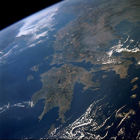
Titre : Greece October 1989
Description : (La description de cette image n'existe qu'en anglais)
The terrain in this high-oblique, northwest-looking photograph is indicative of the rugged, mountainous landscape characterizing most of Greece. Two major landform regions are captured in this photograph—the northwest-southeast-trending Pindos (Pindhos) Mountains in central Greece north of the Gulf of Corinth (Korinthiakós) and the Peloponnesus (Peloponnisos) Peninsula south of the Gulf of Corinth (center of the photograph). The Pindos Mountains, a massive continuation of the Dinaric Alps of Albania and the former Yugoslavia, make the land inhospitable and travel difficult. This rugged terrain caused the Greeks to become a seafaring people, second only to the Norwegians in Europe. The capital city of Athens (lighter area) is barely discernible along the southern edge of the broad peninsula near the eastern edge of the photograph. The Peloponnesus Peninsula, connected to the mainland by the Isthmus of Corinth, has been likened to a hand with a thumb and three fingers. The main part of the hand is Arcadia, the central mountainous area, which is a southeastward continuation of the Pindos Mountains. Greece is flanked on the west by the Ionian Sea and on the east by the Aegean Sea.
|
|

